


From highways to skyways: charting Hong Kong and the GBA’s aerial future
For a city defined by dense urban planning and its strategic role in the Greater Bay Area, the Low-Altitude Economy (LAE) is now a strategic priority to build a new dimension of sustainable connectivity.
The journey towards Advanced Air Mobility (AAM) in Hong Kong is rapidly accelerating from policy vision to tangible reality. The 2024 Policy Address laid the crucial groundwork by launching the LAE Regulatory Sandbox, a move that has already enabled pioneering trials. Building on this momentum, the 2025 Policy Address has firmly cemented the government’s commitment by announcing a dedicated Action Plan on Developing Low-Altitude Economy. This plan outlines a comprehensive strategy to “formulate a management regime for unconventional aircraft” and develop essential infrastructure, including vertiports and a smart low-altitude traffic-management system.
Beyond logistics: The multifaceted value of LAE
While logistics is a powerful initial driver, the LAE promises a broader revolution — a paradigm shift in transport and urban planning. The government’s Action Plan rightly focuses on diverse applications, from cargo delivery to emergency response and aerial sightseeing. Imagine eVTOLs providing rapid, point-to-point transit that bypasses congested roads, connecting the Northern Metropolis to Kowloon or Hong Kong to Shenzhen and Zhuhai in minutes. This fundamentally enhances how the city functions while supporting broader ESG and sustainability goals through reduced urban congestion.
From concept to reality: Navigating the AAM skyway
Unlocking this potential from standalone trials to a connected LAE ecosystem requires a structured foundation to address the critical concerns of safety and integration highlighted in the Policy Address. The solution lies in the “skyway” — the operational backbone of the AAM ecosystem.
More than a flight path, a skyway is a digitally managed airspace system, aligning with the government’s plan for 3D spatial data and smart traffic management. AECOM’s planning leverages digital twins and AI-assisted spatial analysis to create scalable skyway networks for the safe, orderly, and efficient flow of eVTOL traffic. This transforms open sky into a managed public asset that aligns with long term sustainability objectives.
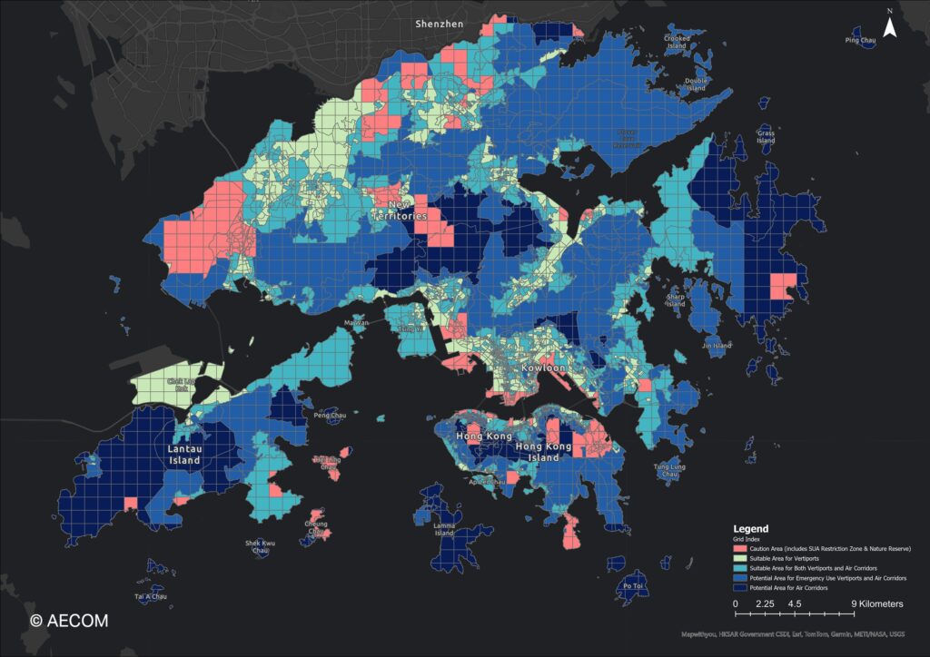
Figure 1: Feasible grids for eVTOL air corridor and vertiports
AECOM’s comprehensive spatial analysis leverages built environment data, building footprints, demographics, and remote sensing imagery to assess vertiport and air corridor feasibility across Hong Kong at 1 km resolution. This data-driven framework enables strategic vertiport and air corridor infrastructure deployment that balances operational efficiency, safety, and environmental protection across Hong Kong’s diverse landscape.
The grids are classified into five (5) categories:
- Red: Caution area for both vertiport and air corridor planning due to existing SUA restriction zones and nature reserves
- Yellow: Suitable area for vertiports, being close to residential and commercial activities
- Cyan: Suitable area for both vertiports and air corridors, located near residential zones in less dense regions
- Blue: Potential sites for emergency-use vertiports and air corridors, characterized by higher permissible flight altitudes and sparse population
- Dark Blue: Areas primarily suitable for air corridors
Leveraging proven expertise for a new frontier
Our approach is grounded in both global and local experience. From conducting Vertiport Integration and Analysis in the Middle East, to establishing the United States’ first interstate AAM corridor, our team has been involved in pioneering projects that offer valuable insights into the evolving landscape of LAE. AECOM’s participation in the Sandbox initiative and experience in the development of Northern Metropolis deepens our knowledge in local skyways and vertiport planning. This, coupled with our long-standing role in Hong Kong’s major transport planning and our work developing the 3D Digital Map for the Lands Department, provides an unparalleled understanding of the city’s urban planning and comprehensive geospatial data for spatial analysis. This experience is directly applicable to designing the AAM skyways and infrastructure called for in the 2025 Policy Address.
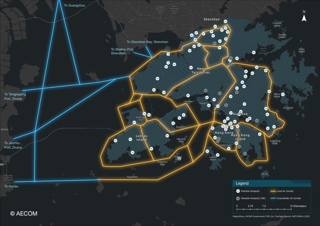
Figure 2: AECOM’s vision for a GBA skyway network
Building on our spatial analysis, we propose a comprehensive vertiport network and air corridor system that establishes Hong Kong as the central hub in a regional AAM ecosystem. The network comprises approximately 370 km of local air corridors throughout the city and 170 km of cross-boundary skyways directly linking key economic centers like Shenzhen, Guangzhou and Zhuhai. Our design carefully considers existing airspace restrictions, commercial aviation routes, and general aviation flight paths to ensure safe integration. The Northern Metropolis serves as a vital gateway, facilitating rapid, seamless eVTOL transit that strengthens the GBA’s position as a fully integrated, multi-modal economic zone.
A three-step approach for Hong Kong and the GBA
Our methodology for supporting the government’s Action Plan is built on three pillars:
- Demand-driven spatial analysis: Using advanced data analytics and our 3D mapping expertise to identify optimal vertiport locations and routes, directly supporting the government’s infrastructure planning goals
- Safety and regulation by design: Proactively embedding safety and ESG considerations into the skyway’s blueprint, helping to inform the new regulatory regime for aircraft over 150 kg as outlined in the Policy Address
- Foster regional collaboration: Championing coordination with GBA stakeholders to create seamless, cross-boundary air corridors, a key step in realizing the full potential of the LAE for the region
Conclusion: A sustainable and connected aerial future
With the 2025 Policy Address providing a clear Action Plan, the focus now shifts to execution. The sky is the next frontier for regional integration, and Hong Kong is well-positioned to lead the future of LAE by taking a strategic approach to AAM and skyway development.
AECOM’s role is to support this initiative by leveraging our unique urban planning insight and hands-on sandbox experience to help design a safe, efficient, and sustainable aerial network. Together with our partners, we aim to make eVTOLs a cornerstone of a future-ready transport system for Hong Kong and the Greater Bay Area.