


Digital cities in action: Meet Jamie Wong
Our Digital cities in action series gives you an inside look at our technical experts in the digital sector around Asia. This week, we’re highlighting a leader from our Digital team in Taipei whose curiosity about landscapes and passion for geospatial technology has driven a career focused on bringing digital innovation in the field of Geographic Information System (GIS).
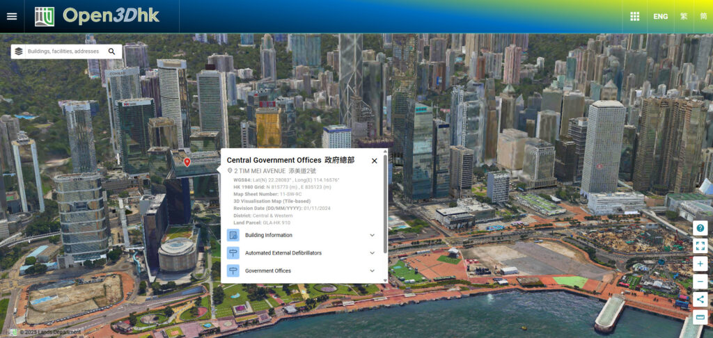
Jamie Wong is the digital lead and senior GIS analyst, Taipei. Her journey with AECOM began in Hong Kong, where she played a key role in advancing digital capabilities and supporting digital transformation initiatives for the government, including the 3D Visualisation Map, a groundbreaking 3D map that forms part of Hong Kong’s smart city blueprint. She now drives digital integration and workflow optimization, leading the Taiwan teams in delivering smarter solutions for planning and design. Her work reflects a commitment to shaping more connected, accessible and sustainable cities through the power of data and innovation.
What inspired you to join the industry?
I’ve always been fascinated by nature and curious about how landscapes are formed. That passion led me to major in Geography in college. During my studies, I discovered Geographic Information Systems (GIS) and realized how much I enjoy working with maps — especially those that reveal the contours and elevations of topography. Maps aren’t just visual tools; they tell stories through data and projections. They offer countless ways to present information and can be interpreted from multiple perspectives. Beyond navigation, maps serve as powerful tools for analysis, planning and understanding the world around us. That realization sparked my interest in applying GIS professionally, which eventually brought me to AECOM as a GIS Analyst.
What is an impactful or favorite AECOM project you’ve worked on?
One of the most memorable projects I worked on was developing a 3D outdoor pedestrian network in Hong Kong. We developed a detailed 3D network that identifies stairs, escalators, lifts or covered walkways for the entire Hong Kong territory. These details enable people to navigate Hong Kong’s complex urban matrix with ease. For example, wheelchair users or visually impaired individuals, can prioritize accessible routes based on their needs, as it is also possible to select covered walkways during rainy days.
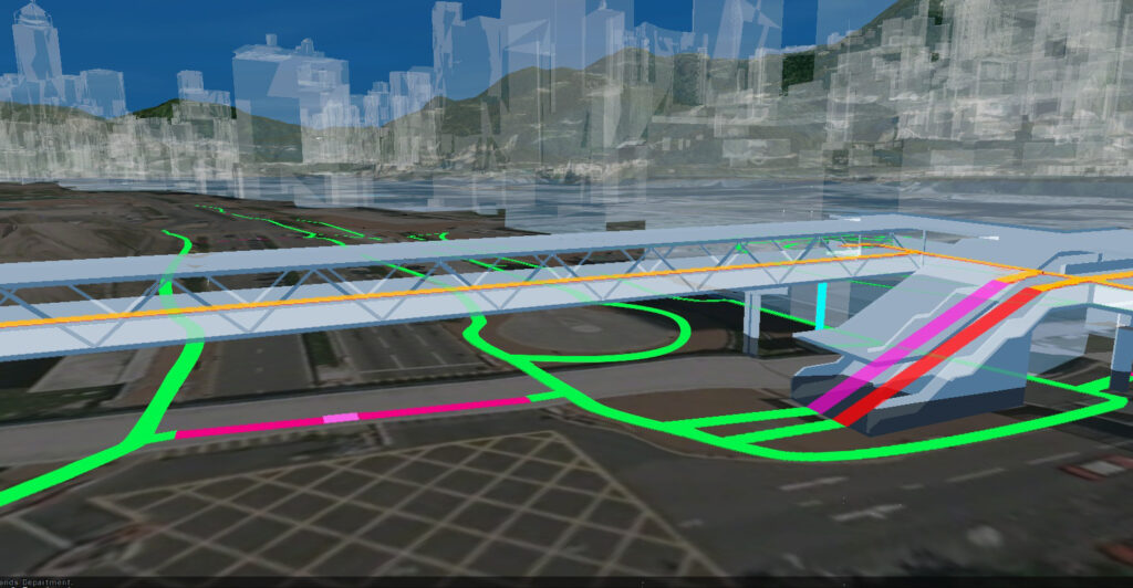
Building this dataset was challenging. It required meticulous data checks, so we developed validation rules and automated them into a checking program. The effort paid off because the data now supports multiple applications, such as walkability and accessibility analysis, and even contributes to urban planning for a more pedestrian-friendly city.
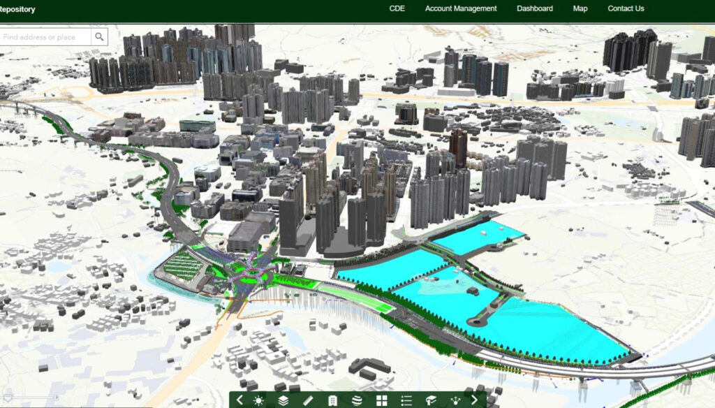
This was my first major project at AECOM, and it opened my eyes to the importance of data in creating digital cities and the power of spatial analysis — overlaying different geospatial data layers to solve real-world problems. Since then, I have worked on establishing GIS data standards to support Common Spatial Data Infrastructure (CSDI), integrating open BIM and open GIS data by establishing Government BIM Data Repository, and building up the 3D Visualisation Map — all of which made me realize the importance of data sharing, governance and standardization. These projects gradually form parts of Hong Kong’s Digital Twin, which acts as the foundation for enabling more data linkage for analysis and better decision making.
How do you see Digital and GIS evolving?
Automation has been one of the most rewarding aspects of GIS for me. Early in my career, I worked on projects that required constant GIS analysis and integration with CAD and BIM data. Every design iteration means importing data and running analyses repeatedly, which is a time-consuming process. So, we developed automated workflows and custom programs, which saved us time and allowed for better design and precision.
That’s how my role has been gradually evolving around digital transformation. Understanding workflows, data inputs, outputs and conversion, and most importantly the “pain” that our colleagues experience in manually doing tasks, has been a key driver in digitizing and streamlining our daily work. This journey has expanded beyond the Digital team to other business lines, and from our Hong Kong office to other locations, such as Taiwan, where I now serve as Digital Lead, driving automation initiatives and improving efficiency. Adding a fresh perspective, our team partners with business lines to organize and standardize workflows while collaboratively exploring potential digital and AI tools.

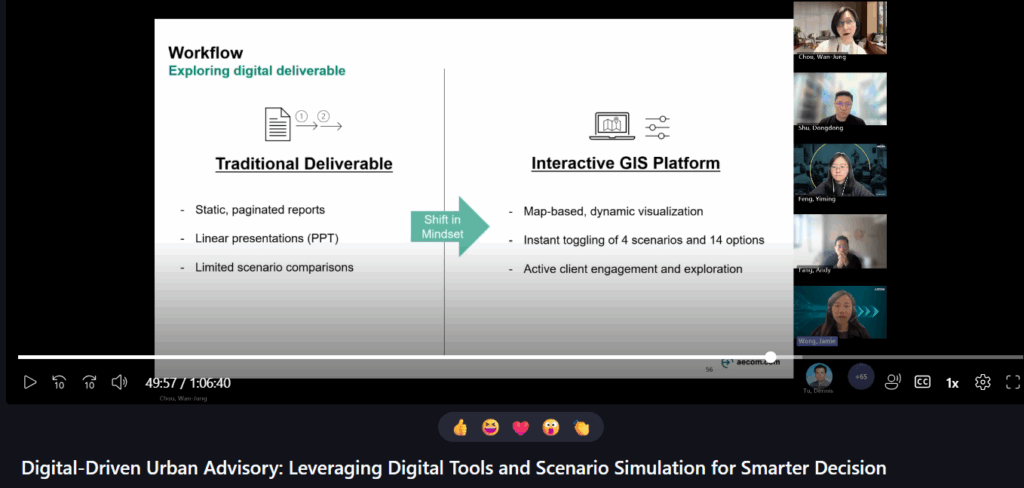
Recently, I contributed to an urban planning project in Taiwan aimed at showcasing AECOM’s Urban Advisory services. Rather than delivering a single recommendation, we collaborated with the client to capture their priorities and developed a decision-making matrix offering multiple scenarios. My role focused on creating an interactive geospatial web platform to visualize these options in a dynamic and user-friendly way. This approach exemplifies digital transformation, shifting from static, paginated reports to an interactive experience that fosters active client engagement and meaningful feedback.
With AI, I see the potential to further automate processes. This can lower entry barriers, making automation accessible without requiring deep coding expertise. Technology is advancing rapidly and we’re heading towards fully digital environments. Each day brings new possibilities, which is exciting. I’m grateful to be part of this digital journey and look forward to seeing digital and geospatial technology continue to evolve as a key driver of smarter and more connected infrastructure and cities.
Share a piece of career advice.
Stay curious and embrace change. Whether it’s GIS, digital transformation, AI or construction consulting industry in general, we thrive on innovation like automation, data integration and emerging technologies. Keeping track and learning can be overwhelming sometimes, but adaptability and problem solving will set you apart.