Emulating nature
Protecting communities from flooding relies on more than building higher walls. Flood risk specialist Cathryn Spence looks at how working with nature can reduce the amount of water that enters a town and make traditional defences more resilient in the long term.
In December 2015, the UK experienced some of the worst floods that we’ve ever seen. Storms Desmond, Eva and Frank left thousands of families homeless not only during one of the coldest months of the year but also at what, for many, was supposed to be the most special time of the year. The destruction left behind is a very real reminder of the lasting devastation flooding can cause; news reports at the time estimated a £1.3 billion clean up bill, with entire communities still counting the emotional toll.
Climate change and its propensity to contribute to extreme flooding events is here to stay, bringing with it the likelihood in the UK of even wetter winters, like those experienced at the end of 2015. But there is no single, right way forward — to reduce the impact of floods we need to think beyond building higher walls.
More than risk management
Natural flood risk measures use natural processes to store or slow down water before it reaches communities and can help relieve pressure on downstream flood defences such as engineered barriers. Integrated within the landscape to increase water storage at different locations throughout a catchment, natural flood risk management (NFRM) complements hard defences that are already in place.
Some NFRM examples include planting woodland to help soak up rainfall, increasing wetland areas by realigning engineered defences and re-introducing meanders into a river to slow the flow of water and decrease river bed erosion. As well as reducing flood risk downstream, working with nature can improve local ecology and enhance biodiversity. These changes can also be easily integrated with other natural, sustainable flood reduction and water management strategies, such as blue-green infrastructure, sustainable drainage systems (SuDS) and water sensitive urban design (WSUD).

A shared vision for the Elwy
Persistent, intense rainfall in November 2012 caused the River Elwy in North Wales to rise more than three metres above its normal level, flooding some 320 properties within St Asaph in Denbighshire. The flooding started mostly in the downstream section of the Elwy, overwhelming local flood defences, such as the town’s raised earth embankments.
In response to this flooding, and as part of NRW’s efforts to develop a long term flood risk management plan for the area, AECOM worked with them to identify ways natural catchment-scale processes could complement the hard engineered-defences already in place in St Asaph.
Modelling and mapping
Using aerial imagery, Geographical Information Systems (GIS) and flood simulation software, such as Info Works ICM, and other innovative modelling techniques, we examined how the Elwy catchment responds to extreme rainfall to determine when the river flows at its highest in St Asaph. We also looked at how implementing NFRM, by for example, planting more trees along the river and river restoration, could reduce flood risk in communities downstream, including St Asaph and Llanfair Talhaiarn.
Identifying opportunities
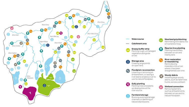
Through the study we identified around 300 opportunities to enhance natural flood risk management within the Elwy catchment — see the catchment map above. Some of the options include building dams with timber or wood to increase farmland water storage, blocking artificial drainage ditches on moorland with grip blocks, increasing wetland areas, realigning manmade flood defences to reconnect floodplains and re-meandering the river where it has been straightened to slow its flow. As part of our ongoing partnership with NRW we’re now working with them to continue researching NFRM in the catchment.
Our work with NRW shows that enhancing nature can complement traditional flood defences to increase a community’s flood resilience; by holistically managing floodwater across an entire catchment you can reduce a river’s peak flow and the amount of water that enters a town in the first place.
New thinking
Looking at the whole catchment to protect communities will require authorities to think outside of the box; a catchment scale approach can work, but only as part of the bigger flood risk management picture. And because every catchment is different, there is no one-size-fits-all fix. A mix of solutions, both manmade and natural, is needed — if we are going to manage water and climate change impacts.
As well as reducing flood risk downstream, working with nature can improve local ecology and enhance biodiversity
Identifying and overcoming challenges
Organisations such as the EA, Natural Resources Wales (NRW) and the Scottish Environment Protection Agency are studying the effectiveness of natural flood management in the UK. But, maintaining and enhancing our natural watercourses and catchments presents certain challenges.
Multi ple landowners within a catchment often have conflicting priorities, while some existing land management techniques can increase water runoff. Supporting landowners and communities to utilise techniques that are right for them and the local catchment means local authorities, statutory flood management organisations and entire communities will need to come together to implement NFRM. It will also take new, innovative ways of generating funding to help get schemes off the ground.
NFRM measures provide wider benefits or ‘ecosystem services’, such as regulation of local climate and the provision of green areas for recreation.
Wider benefits
The added benefits of NFRM measures are also evident; creating water meadows can create accessible green space; retaining top soil on farms can improve water quality; planting vegetation in steep gullies can reduce runoff; creating grassy buffer strips, woodlands and wetlands can regulate local climate. Providing ecosystem benefits such as these could also help UK organisations like the EA and NRW achieve their statutory duties under the Water Framework Directive, Habitats Directive and Flood Directive.
Innovative funding
NFRM provides wider benefits or ‘ecosystem services’, such as regulation of local climate and the provision of green areas for recreation. Identifying these services and assigning them a monetary value can help generate investment; for example valuing green areas could encourage communities to fund and manage them. This approach called payments for ecosystem services is gaining a lot of ground across the water industry, find out more in our becoming business article here.
Strengthening and sustaining
 The link between nature and reducing urban flood risk is strong. However, natural flood management is now largely undervalued in long term flood risk management plans mostly due to a lack of understanding and funding options. NFRM isn’t always the most straightforward option — for example, the issue of multiple land ownership across a catchment and conflicting land management priorities make it a complex but worthwhile investment.
Investment in this holistic flood risk management will require more cooperation between NRW, the EA, local councils, landowners and wider communities to help drive research into effective strategies. By appreciating how the natural environment works, we can develop ways to restore and enhance it, to create more resilient flood risk management strategies and a more sustainable future.


