


Going underground: untapped land uses beneath our feet
In the past, going underground was a journey into unchartered territory, but the combination of technologies such as Virtual Reality, photogrammetry, Building Information Modeling (BIM) and 3D spatial data is making below ground development a much less risky prospect. AECOM innovation experts Thomson Lai and Roger Luo, in conjunction with the Hong Kong SAR Government’s Civil Engineering and Development Department, explore the use of these technologies in the planning and design of underground space developments.
While Hong Kong has a long history of using underground space for commercial and public facilities, many of these projects were simply an extension of the building on top of them, with limited connection to the city around them. As urbanization continues its upward trend and our perceptions of space — personal and public — are constantly evolving, this use of layered technologies to explore the underground holds the potential to revolutionize urban liveability and create synergies with the surrounding urban context.
AECOM, commissioned by the Civil Engineering and Development Department (CEDD) of the Hong Kong Special Administrative Region (HKSAR) Government to undertake a study of underground development in an urban space, has explored ways of integrating the latest innovative technologies, including Virtual Reality (VR) and photogrammetry technologies with more widely used techniques in the industry, such as Building Information Modeling (BIM) and 3D spatial data to improve communication among the different parties involved in the planning and design process of underground space.
This novel combination of technologies has resulted in time savings, increased efficiency and cost benefits as well as greatly enhanced cooperation and the ability to virtually collaborate without the need for travel to a project site. On one project, outlined below, the use of photogrammetry technology to create a 3D model of the existing site saved three weeks time from the site survey, while sharing the site reality model with the designer for performing the parametric design saved another two weeks. Integrating various feature models into a visualization model for the Virtual Reality simulation saved another two weeks by amalgamating information to form a holistic review with different parties. Further, it saved client comment time as 3D visualizations facilitate the design detail and constraints of the project. Since the design team did not need to travel to Hong Kong, this saved around $100K HKD.
Particularly in high density cities, where land value is high and greenfield developments are hard to come by, the ability to map the underground more effectively and efficiently may open a world of possibilities.
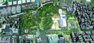
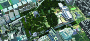
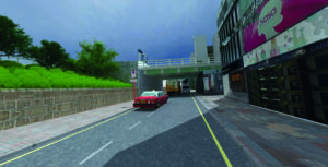
This combination of technologies was first used to see how an urban park in Honk Kong that is close to a railway station could be better integrated to its surrounding area. The park is surrounded by densely developed multi-story buildings of mixed residential, commercial and retail use. For initial planning, AECOM and CEDD wanted to capture the existing environment in a 3D model to study how the park related to a wide range of facilities at ground level. But while there was 3D data on the buildings surrounding the park, there wasn’t any available 3D data on the park itself. That’s when we started going underground.
To build a more complete picture, we used Hong Kong government 3D spatial data[1] from the Lands Department to create that 3D model of the park then combined it with aerial photogrammetry technology. We shared the resulting model – complete with hard and soft landscaping and areas of interest within the park – with our partnering architecture design company based in Japan who had enough detail to be able to do many things that would usually have required travel to Hong Kong. This included measuring the space, seeing the topographic setting and the detail of the proposed site, as well as gaining an understanding of how the underground project would relate to the existing environment.
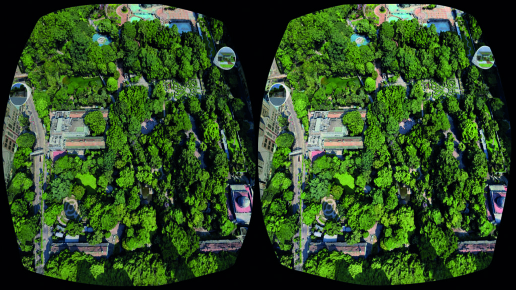
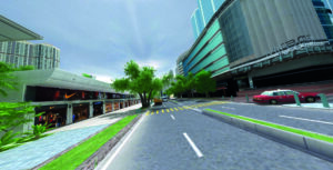
In the early stages of the design, a BIM model was created using the architectural design model which allowed all parties involved to communicate effectively and with a great level of detail. The BIM model was then combined with the site reality model (3D + photogrammetry) to create a Virtual Reality (VR) model that could be experienced on a computer screen. This virtual environment gave designers, planners, engineers, consultants and client representatives a realistic and life-sized place to walk and talk through the various aspects of the project.
After we layered on the virtual reality component, the resulting 1:1 representation of the project site also enabled 360-degree panoramas suitable for mobile VR devices used at in-person public consultations, as several mobile devices can be deployed at one venue. Panoramas can also be hosted on a website to reach a wider audience. The next level we’re exploring is a computer-connected VR device which would allow for more detailed design review and for users to interact with the virtual underground space design at a real-world scale. These representations could also be used in a virtual consultation room using AECOM’s interactive web-based tool.
Another benefit to this layering of technologies is that visualization models are not limited to the illustration of design details; data can be converted to other software to view shadow, noise and traffic impact assessments; 4D (BIM) simulation can also help to visualize the construction process.
This approach is unique because the novel integration of these innovative technologies has rarely been investigated within the framework of a single project and never-before used to explore underground space. Stakeholders often think only of BIM, but with an open mind this concept can be (and has been) replicated with different combinations of the various available technologies to suit the needs of other clients and projects.
Our study demonstrates the clear benefits for all parties involved in the planning and design of the conceptual scheme for underground space development in densely populated urban areas. Designers, planners, clients and consultants can visualize the components of a design at a 1:1 scale in ways that cannot be matched by 2D or 3D software alone. For the public, the realistic nature of the VR-based model brings the project and its full potential to life.
Learn more about this and other explorations of the potential of subterranean space to revolutionize the future urban experience in the new book Underground Cities: New Frontiers in Urban Living, introduced here.
AECOM would like to acknowledge the Head of Geotechnical Engineering Office and the Director of the Civil Engineering and Development Department, the Government of the Hong Kong Special Administrative Region, for the permission to publish. The usage of material was authorized by ACUUS, the Associated Research Centers for the Urban Underground Space. The Government of the Hong Kong Special Administrative Region does not accept responsibility for the accuracy, completeness or up-to-date nature of any reproduced versions of the material concern.
Unless otherwise indicated, the photographs found in this article are subject to copyright owned by the Civil Engineering and Development Department (CEDD). Prior written consent is required for a third party who intends to reproduce, distribute, display or otherwise use such photographs in any way or for any purpose. Such request for consent shall be addressed to the CEDD via email at enquiry@cedd.gov.hk
[1] 3D Spatial Data is a set of territory-wide digital 3D model data created to represent the shape, appearance and position of various types of ground features including building, infrastructure and terrain.