


Unlocking the power of context: The crucial factor in communicating flood risk data
Extreme weather events have become increasingly prevalent worldwide with increased flooding, drought, wildfires, and cyclones. Concurrently, we are seeing increasing interest across our society in climate-related discussions, including the investment in climate-resilient communities and related infrastructure. Effectively communicating the decisions being made, the data behind those decisions and the progress being made in improving the resilience of our communities can be a challenge.
In this article, we explore five challenges related to communicating flood risk for major infrastructure projects, the current tools utilized to overcome them, and a contemporary solution for stakeholder engagement.
Five challenges when communicating flood risk
- Complexity of the information: Effective communication of flood risk requires a nuanced understanding of natural factors – meteorology, hydrology, topography and land use – and the impact of human actions such as urbanization, deforestation, and construction in flood-prone areas. Stakeholders have varying levels of knowledge and understanding of these impacts, so communicating this information clearly and concisely can be challenging.
- Uncertainty and probability: Flood risk assessments involve dealing with complex uncertainties and probabilities. Many members of the communities where we work are not experienced in statistics and complicated probability-based frameworks or know how to read and interpret flood model outputs. Advancements in flood modelling software and increasingly complex regulatory frameworks have widened the gap between our data and our ability to communicate it effectively.
- Stakeholder diversity: Stakeholders have varying levels of knowledge, interests, and priorities. Stakeholders may include individuals, landowners, developers, insurers, businesses, and government agencies. Tailoring flood risk communication to different stakeholder groups and addressing their specific needs whilst keeping this information concise is time-consuming and challenging.
- Communication channels: Identifying the most effective communication channels to reach different stakeholders and ensuring timely dissemination of information is critical. However, determining the appropriate channels and timing that align with stakeholders’ preferences and routines can be difficult, particularly when dealing with diverse groups.
- Emotional and psychological factors: Flood risk communication can evoke strong emotions and psychological reactions. Stakeholders may experience fear, denial, or complacency, which can influence their understanding and response to the information. Their own individual situations and experiences with flooding in the past can also significantly affect these emotional responses. Addressing these emotional and psychological factors is crucial for effective communication.
Context is key
In this digital era, our communities are provided with a myriad of ways to consume and engage with information. They now seek more detailed answers to complex problems, yet the overwhelming abundance of information we get every day restricts our attention to lengthy information. Having access to data and information alone no longer provides a satisfactory outcome. It’s, therefore, essential to understand the specific concerns and questions pertaining to each stakeholder group.
For instance, residents near a proposed infrastructure project may want to know how much deeper floodwaters might become on their property after the project is built. In such cases, it would be more effective to make comparisons using an actual historical flood that people can relate to rather than communicating a statistical and often misunderstood Annual Exceedance Probability (AEP).
Complex data requires a creative approach
Historically, the complexity of flood modelling data has kept this ‘black box’ of information largely hidden from the public. However, the increasing public scrutiny and community interest in improved environmental management are driving new and alternative solutions for improving the effective communication of this data and information.
Traditionally, hard copy, static flood impact maps are produced for major infrastructure projects to compare the existing case (current situation) with the developed case (after development) modelling results. Understanding them requires impacted landowners and other stakeholders to trawl through hundreds of static PDF maps to understand how the flood risk is likely to change and which changes exceed the flood performance targets. Then to find the direct impact on them, they must locate their property or area of interest. The lack of interactivity on these static maps and the disconnect with the technical reporting means they may not even be able to see the predicted impact in an easily digestible format.
To ensure these complex and convoluted concepts are communicated effectively to stakeholders, an engaging, intuitive, and interactive platform is required that can effectively navigate between technical detail, visualizations, maps, and graphics.
The optimal method for communicating flood risk data: An online, interactive, and visually rich platform
An online flood map portal provides site visitors with a visually immersive and user-friendly experience designed to cater to various audiences. It effectively communicates technical information such as flood mapping, making it accessible and understandable to the community, regardless of their level of technical knowledge. Allowing the community to search for their address and interact with an adjustable map to customize their experience of the information enables everyone to find the answers they require.
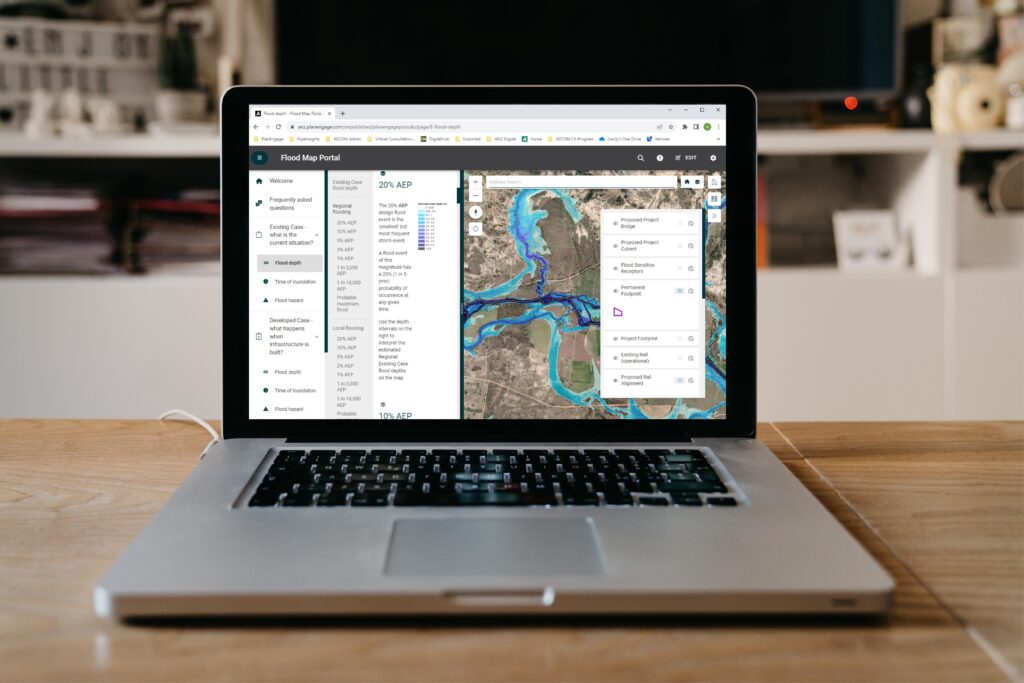
The Flood Map Portal, created by AECOM for a major infrastructure project, provides this enhanced experience for the community. Hosted by PlanEngage™, the Flood Map Portal simplifies the creation of this style of complex and data-rich report into a visual and interactive online platform. It offers the appropriate level of technical content, interactive mapping tools, data visualization and online surveys to make data easier to search, understand and collect feedback from the community. This version of advanced data communication has proven to be a practical approach for presenting flood modelling and flood performance criteria assessment outcomes for this project.
Additionally, text-based technical information displayed alongside flood maps makes it easy for users to access and interpret both types of data simultaneously. This has been a challenge in the past as flood maps and technical information were often presented separately in hard-copy reports with a fixed scale or required users to navigate between different pages, which can be difficult on a computer screen or hard-copy document.
PlanEngage™ allows flood management practitioners to transform complex modelling data and technical reports into actionable knowledge. This, in turn, empowers the communities we serve to understand and interpret the data, enabling them to make informed decisions based on sound judgment. Comments and reviews posted by users act as immediate feedback loops to the project team and drive further engagement and understanding.
During a community engagement event about flood risk, we saw first-hand the benefits of making flood risk data more accessible. We used a 3D experience from a digital twin to inform and engage vulnerable residents in a frequently flooded neighborhood in Australia. In doing so, we helped them to understand flood behaviors, gain their trust and explore ideas which help alleviate anxiety and address future flooding.
Overall, the online Flood Map Portal, significantly enhances transparency in the planning and development process, ultimately leading to the successful implementation of more resilient and impactful projects.
Final thoughts on flooding
With the technological advancements of digital modelling, AI, automated design, increased data analytics capabilities and cloud-hosted reporting and visualization platforms, the tools, and technologies to make this process more efficient and effective are now becoming readily available. How we use this technology to communicate flood modelling data more effectively is only just starting to be explored and provides an exciting opportunity to enhance this space.
We are presented with an exceptional opportunity to optimize the use and dissemination of flood modelling data to ensure that the infrastructure projects we design and maintain are more considered, better designed, and ultimately deliver superior outcomes for the communities in which they are located.