


COP26 in Glasgow: tools for creating a just transition in the UK’s major cities
For resilience and net zero strategies to succeed in the long term, new infrastructure needs to be designed specifically to have a positive impact on the communities it serves. To coincide with COP26, landscape and active travel specialists Karen Clifford and Paul Matthews share lessons learnt from the delivery of strategically important projects across Glasgow, Edinburgh, Manchester and Birmingham.
In the UK, climate change and the levelling up agenda are forcing a rethink on infrastructure investment. That is certainly the case in Scotland, where legislative framework for emissions reduction is underpinned by a legal commitment to deliver a ‘just transition’.
The Scottish government defines a just transition as ‘both the outcome – a fairer, greener future for all – and the process that must be undertaken in partnership with those impacted by the transition to net zero’. To deliver on its policy commitments, the Scottish government has set up a dedicated Commission who will be tasked with undertaking ‘meaningful engagement’ with local communities as well engaging and collaborating with ‘with other sources of expertise’, including relevant Scottish government advisory bodies on climate change and inequality amongst many others.
As Colin Wood, AECOM CEO for Europe and India said recently at the launch of the UK COP26 Presidency’s ‘Visions for a Net Zero Future’: “Efforts to tackle climate change will have limited success without the involvement of local citizens; leveraging that local knowledge will be key to achieving a resilient, net-zero future.” As infrastructure and built environment consultants, we are committed to delivering sustainable legacies. Listening to community voices to achieve a deeper understanding at a local level helps our multidisciplinary teams gather evidence to find the best solutions to our clients’ most complex challenges.
In this article we explore three different approaches that can be used to create equitable infrastructure needed to meet wider levelling up and net zero ambitions. We take Glasgow as our starting point, then draw on strategically-important transport planning, active travel and flood management projects across other major UK cities including Edinburgh, Manchester and Birmingham.
Enhancing engineering-led schemes through nature-based solutions
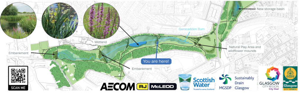
Managing flood risk is a priority for Glasgow. Climate Ready Clyde estimates that 21,500 extra homes will be at risk of flooding by 2080.
Several schemes of strategic importance that manage excess surface water have been initiated in the city region under the Glasgow City Region City Deal and through the collaborative Metropolitan Glasgow Strategic Drainage Partnership (MGSDP). One of these projects is in Drumchapel, an area of deprivation identified as needing further support to tackle complicated socio-economic issues. As well as protecting areas downstream from flooding, the project needed to deliver additional social value for the people of Drumchapel.
Embedding the landscape team (which included our in-house ecologists and arborists) with the planning and engineering team from the outset enabled us to deliver additional benefits, as having a multidisciplinary capability meant that we were able to use natural restorative processes to cost-effectively enhance traditional engineering solutions.
For example, we knew that local people had difficultly traversing the site, so we installed robust bridges to make accessible crossing points over the Garscadden Burn, ensuring that the footpath gradients were suitable for wheelchair users. In some cases, a light design touch was all that was needed: boulders were retained to provide simple, natural play opportunities.
Any design solution must work for the local community in the longer term. Looking at flood management schemes through an environmental lens builds this resilience. We reshaped some of the retained soil to create naturally contoured berms so that they would act as an emergency reservoir in times of extreme rainfall. In addition, we chose native species to replicate the natural habitat, and planted an understory of native ground cover, a wetland meadow mix and trees that will need minimal intervention over the five-year implementation period. To be successful however, this approach requires hard evidence and a very firm understanding of existing soil, hydrology, weather and climate conditions.
These environmental interventions are communicated in a highly pictorial and visual way by new interpretation panels on The Drumchapel Way, which have been developed in conjunction with Glasgow City Council’s access and biodiversity officers with input from Forestry and Land Scotland.
Placing a higher weighting on socio-demographic factors
During the stakeholder consultation for the recently-conducted Strategic Transport Projects Review (STPR2) for the Glasgow City Region, the climate emergency was cited ‘as an opportunity to make transport investment decisions that encourage people out of private vehicles through better active travel provision and better public transport’. To make this a reality, active travel across Scotland has just received a huge injection of funding. By 2024-5, at least £320 million will be allocated to active travel, taking the proportion of total spend from 3.5 per cent to ten per cent.
Historically, transport investment has been targeted using traditional factors, such as economic growth, congestion and road safety. By placing a higher weighting on socio-demographic objectives, active travel and public transport accessibility indicators however, transport planners have an opportunity to identify schemes in many new locations that meet levelling up and environmental agendas. This offers potential to create a more balanced infrastructure delivery plan.
In England, we used this novel approach during a macro study of the Key Route Network (KRN) in Birmingham and the wider region undertaken on behalf of Transport for West Midlands (TfWM). By linking our evidence-led assessment process with the emerging environmental and socially inclusive agenda, we were able to deliver 44 conceptual scheme plans that clearly indicate sites where investment would enhance local conditions for active travel, improve the immediate environment and improve residents’ health and wellbeing. The approach also ensured areas of low long-term investment were brought to the fore. Early business case style-documents were developed for each scheme to discuss the key connectivity challenges identified and suggest indicative costing and high-level delivery timescales for targeted measures. The study also included the development of five area-wide, thematic propositions on the subjects of 15-minute neighbourhoods and mobility hubs, electric vehicle charging and digital connectivity.
The process was designed to demonstrate alignment with a broader set of strategic objectives, to inform short, medium and long-term delivery plans, and to enable best use of future funding opportunities. We are now assisting TfWM in the development of a KRN delivery plan and monitoring framework.
An evidence-led approach to low traffic neighbourhoods
Low Traffic Neighbourhoods (LTN) create safer and more comfortable street environments to walk, cycle, wheel and spend time in by reducing the volume and speed of traffic. They are key elements within wider city net zero transport strategies that encourage and increase the use of sustainable and active modes of transport, and are fundamental to Glasgow’s Liveable Neighbourhoods.
However, the coronavirus pandemic has taught us that LTNs can be challenging to implement successfully. By their nature, an LTN encourages and enables fundamental modal shift away from a reliance on private car use. Despite many of the benefits including encouraging ‘active travel’, air quality and safer community-focussed streets, they have been seen to be contentious and divisive as they can fundamentally change how local residents are able to move around their neighbourhoods.
To give local authorities the confidence to make robust decisions on LTNs and to communicate effectively with communities, planning and designs should be evidence-led. Gathering comprehensive data, such as traffic levels, speed, school travel plans as well as sat-nav origin destination analysis for example, provides a clear documentation trail that can be referenced easily. Furthermore, the presentation of data should be simple and legible to allow communities to understand it to build trust in the process.
Increasing conduits into communities directly affected helps gather better information and understand local issues and aspirations. Digital engagement tools are now so advanced that they can include 3D visualisations and map-based feedback. We have been using these tools on proposed active travel schemes across the UK including in East Lothian and in The Bee Network in Manchester to increase the demographic range involved in the consultation process.
Steering groups are another effective route into the community. Corstorphine Connections is an LTN in Edinburgh that has just been approved by Edinburgh Council. As part of a six-month period of intense community engagement, we founded a Community Reference Group (CRG) during the early stages to help set the objectives and provide an additional way for the community to express their views. The CRG included members from community groups, parent councils, businesses, housing associations, bus user groups, the Living Streets group and the council’s Access Panel. Members gave us valuable insight and local knowledge that we fed into the designs.
Initially, the Corstorphine LTN will be delivered under an Experimental Traffic Regulation Order (ETRO). During the trial period, the CRG will continue to meet and feedback on the scheme. We are currently developing a detailed monitoring and evaluation programme that involves a variety of metrics including air quality, traffic impacts, noise and how people feel about and use the new community spaces. In this way, data and evidence will continue to inform the decision-making process while the scheme is in its trial period.
Leveraging local knowledge to achieve a just transition
To achieve a just transition to a low carbon urban economy, new infrastructure must have a positive impact on the communities it serves. Within the public and political environment of delivering transformational net-zero strategies, it is essential that decisions regarding new infrastructure must be transparent, robust, and backed by well-researched hard evidence, of which local knowledge and community feedback must be a huge part.
The importance of continuous monitoring and evaluation of schemes, and listening to those affected, will only improve how projects are delivered in future by building confidence and strengthening the case for change.